Prepare for Floods Across the Southeast with DLAN’s GIS Premium
Trust Emergency Management Software from Buffalo Computer Graphics
Flooding happens frequently across the Southeast in the United States and can lead to high costs. With help from DLAN’s GIS tools, you can be ready for flooding when it happens. View historic, real-time, and predictive data in one unified map to help you prepare for when flooding is coming.
The Features You Need in a Flood Preparedness Software
DLAN uses data from the National Weather Service and Aeris Weather to show current weather and forecasts, allowing you to know and prepare for when heavy rain strikes. Terrain layers can be used to see slopes and develop high-impact awareness areas. Our mapping also allows you to mark demographic developments in predicted flood zones to help design evacuation routes.
Our flood preparedness software lets you combine our different mapping features to create a detailed predictive model. Stream gauges and other sensors can be added to track and view water levels alongside known thresholds. These gauges can also be used to set off alerts from the DLAN system when flooding is likely to occur.
Our toolset allows you to improve how users interact with the data, improving predictions and plans. DLAN’s configuration tools make managing and adding new data sources or base maps quick and easy. Data can be organized into categories on a touchscreen-friendly ribbon, making locating and toggling information on and off a snap.
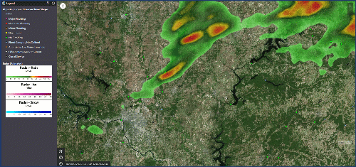
DLAN GIS with Aeris Weather Radar
The Areas We Serve:
- Alabama
- Florida
- Georgia
- Louisiana
- North Carolina
- South Carolina
- Texas
- Virginia
- And More
Try Our Flood Preparedness Software
Start creating and improving your emergency response plan and be ready for when heavy flooding strikes in the Southeast. Learn more about GIS Premium and request a demo.
