
DLAN’s GIS Premium Strengthens Flood Preparedness
Reliable Emergency Management Software from Buffalo Computer Graphics
Flooding is the most frequent and costly natural disaster in the United States, affecting areas across the country. DLAN’s GIS tools can help prepare for flooding incidents.
With DLAN’s GIS users can view historic, real-time, and predictive data all in one unified map. One of the major advantages of DLAN’s GIS over other solutions is the breadth of supported integrations. GIS Premium supports the display of data from most common GIS formats out-of-the-box and also includes a number of custom integrations allowing you to plan a flood response that works with your team and meets your needs.
LEARN MORE ABOUT OUR GIS
Our GIS Offers the Features You Need to Plan Your Response
DLAN can pull in data from the National Weather Service and Aeris Weather to show current weather and forecasts. Terrain layers can be used to see slopes and develop high impact awareness areas. Mapping can also show demographic developments in predicted flood zones to assess likely impacts and create evacuation routes. Flood prediction models, such as visual flood plains and likely critical infrastructure impacts, can be added as layers. Stream gauges and other sensors can be added to track water levels and view them alongside known thresholds. These gauges can also be used to set off alerts from the DLAN system when flooding is likely to occur.
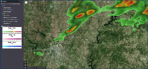
DLAN GIS with Aeris Weather Radar
Tools Integrated into Our GIS
DLAN’s intuitive toolsets allow users to easily interact with this data to improve predictions and planning. DLAN’s configuration tools make managing and adding new data sources or basemaps quick and easy. Data can be organized into categories that appear on a touch screen friendly ribbon, making locating and toggling information on and off a snap.
Geospatial queries can be created to show particular subsets of mapping information. Data can also be exported for use in other applications.
By pulling in information from multiple external data sources, adding planning and modeling data as layers, and integrating real-time sensors and gauges, DLAN’s GIS helps users predict and prepare for flooding incidents. These same tools improve response by giving users one unified area for viewing all geospatial incident data, including ongoing tasks, deployed assets, and live-streaming video feeds. DLAN’s GIS, in conjunction with other tools in the DLAN Emergency Management Solution, improves overall preparedness and response.
Try Our GIS for Yourself
Prepare for spring floods with DLAN's GIS. Contact us today to learn more and to request a demo.
