Incident Management • DLAN • Flood Preparedness
Improve Flood Preparedness and Response with DLAN
Our Intuitive Incident Management Software
Flooding is the most common type of natural disaster in the United States and Canada. Floods can occur at any time of the year and are often caused by heavy rainfall, rapidly melting ice, and levee or dam failure. Although some areas are more susceptible to flooding, such as coastal and riverine areas, flooding can happen anywhere. Flood preparedness is an essential component of a successful emergency response.
Too often emergency managers end up wasting precious response time on tasks that could have been easily completed beforehand, such as entering resources into a database or gathering contact information from key players. Lack of familiarity with response plans and procedures also slow down responses. This is where DLAN, our disaster preparedness software comes in.
DisasterLAN (DLAN) is an all-hazards disaster preparedness system and is the perfect way to prepare, mitigate and respond to one of the most damaging disaster events: flooding. DLAN creates a central repository for all pre-planning information, so your team can simply log in during a response to get to all the information they need and start completing tasks. By prestaging resources, emergency managers can cut down on deployment time, streamline communications, and respond to communities most at risk. DLAN takes information from multiple internal and external sources and displays it on comprehensive dashboards and maps, improving your team’s ability to make decisions quickly.
Try our flood preparedness software for yourself with a demo of DLAN.
What Others Thought About DLAN
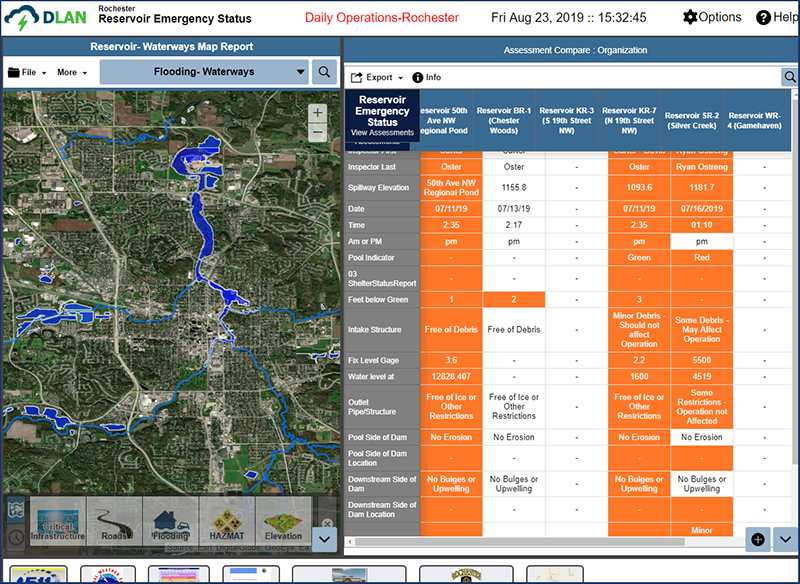
Case Study: Rochester, Minnesota Enhances Flood Preparedness with DLAN
DLAN doesn’t just provide a digital location for a static set of plans, but makes the plan easily actionable with custom workflows and decision-making tools for more effective disaster preparedness. Read our case study on how DLAN helped the Rochester, Minnesota Emergency Management staff was able to incorporate the information they had available to them before their activation to improve response outcomes.
Feature Spotlight: GIS Premium Strengthens Flood Preparedness
By pulling in information from multiple external data sources, adding planning and modeling data as layers, and integrating real-time sensors and gauges, DLAN’s GIS helps users predict and prepare for flooding incidents. Read more about how GIS Premium can improve flood preparedness in our feature spotlight.
