
Powerful Integrated GIS Mapping
Featuring a Common Operation Picture (COP) Viewer
The DLAN Emergency Management Solution includes a fully integrated common operational picture (COP) viewer. With our mapping solution, users can fuse together geospatial information from virtually any external or internal source onto one common display.
Unlike other solutions that require costly per-user accounts to a third-party GIS platform, DLAN’s GIS Premium is accessible to all your DLAN users with no hidden fees. Other benefits of DLAN’s GIS system over similar products include:
- Ease of use
- Interoperability
- Full integration with other DLAN modules
See how DLAN's GIS can be used for wildfire preparedness and response in our latest video
Learn More and Request a Demo for Our GIS Capabilities
Ease of Use
With DLAN’s GIS Premium, anyone can reap the benefits of GIS mapping, with no special training required. Intuitive tools allow users to interact with underlying data in real-time, allowing you to easily manage all relevant information. For example, tools for identifying data and creating buffers allow users to drill down to the data they need for decision making. Data can also be exported for use in other applications.
DLAN’s configuration tools make managing and adding new data sources or basemaps quick and easy. Data can be organized into categories that appear on a touch screen friendly ribbon, making locating and toggling information on and off a snap.

GIS Premium
Interoperability
GIS Premium supports the display of data from most common GIS formats out-of-the-box. For a full list of data sources, please see interoperability and integration.
Integrated Solution
In addition to incorporating key external data, GIS Premium also displays data from other DLAN modules, making it easy to keep all of your information in one place. As examples, deployed assets, video from traffic cameras, and mobile responder-based personnel tracking can be viewed on the map. Users can even add and edit tickets, forms, and assets directly from the map.
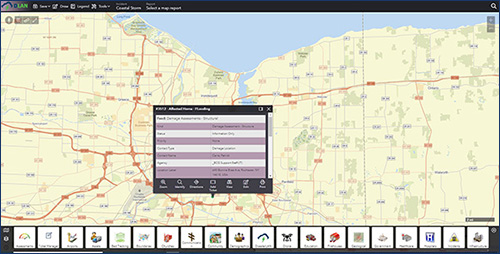
View Ticket on GIS Premium
Contact us today to learn more about GIS Premium or to request a demo.
Key Features
- Intuitive ESRI based Mapping Solution
- Fully Integrates with other DLAN Modules
- Displays Data from other GIS Data Sources